
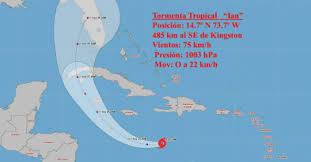
This morning, tropical storm Ian has had little change in its organization and intensity, so it continues with maximum sustained winds of 75 kilometers per hour, with higher gusts, and a central pressure of 1003 hectoPascal. It maintains its movement towards the west, now at 24 kilometers per hour.
At 12:00 m., its central region was estimated at 14.4 degrees North latitude and 75.4 degrees West longitude, a position that places it in the waters of the central Caribbean Sea about 415 kilometers south-southeast of Kingston, Jamaica and about 835 kilometers southeast of Grand Cayman.
In the next 12 to 24 hours, the tropical storm will continue with a similar course and travel speed, tilting its path to the west, northwest and northwest this Sunday, gaining more organization and intensity, with the possibility of reaching the category of a hurricane on Sunday afternoon or the night.
The Forecast Center of the Institute of Meteorology maintains a close watch on the evolution of this tropical cyclone organism, due to the potential danger it represents for western Cuba, given its position and forecast trajectory.
The next tropical cyclone warning for this system will be issued at 6:00 p.m. this Saturday.