")


During this morning, tropical storm Ian maintained a process of organization and intensification, becoming a hurricane. Ian is the fourth hurricane of this hurricane season, all of them formed in the month of September.
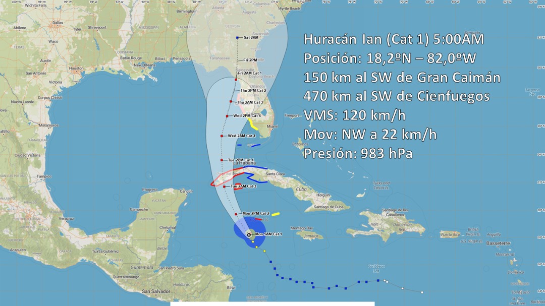
Its maximum sustained winds are 120 kilometers per hour, with higher gusts and the minimum central pressure has dropped to 983 hectoPascal. It is moving with a course close to the northwest, at 22 kilometers per hour.
At 5:00 a.m., its center was estimated at 18.2 degrees North latitude and 82.0 degrees West longitude, a position that places it 380 kilometers south-southeast of Carapachibey, Isla de la Juventud and about 515 kilometers southeast of San Antonio Cape, western end of Pinar del Río.
In the next 12 to 24 hours, this hurricane will tilt its course to the north-northwest, with a similar travel speed, over very warm waters, a favorable environment that will allow this strengthening process to continue rapidly.
From the end of this morning, the clouds will increase in the west of the country, with showers and rains that can be heavy in some localities, mainly on la Isla de la Juventud. The outermost circulation of Ian, in combination with the afternoon instability, can lead to numerous rains in the center of the country, during the afternoon and evening hours today.
With the proximity of Ian to the west of Cuba, the speed of the winds will increase from the afternoon and will reach tropical storm force, with speeds between 65 and up to 80 kilometers per hour, with higher gusts, starting in the south of la Isla de la Juventud and from the night in the south of the west. In the early morning, it will reach hurricane strength, in Pinar del Río.
As of the end of the afternoon, tidal waves will begin on the southwestern and central coast, which will be strong from the night to the south of Pinar del Río and Isla de la Juventud, with coastal flooding starting early Tuesday morning on the southwestern coast.
The Forecast Center of the Institute of Meteorology maintains a close watch on the evolution and future trajectory of this tropical cyclone organism.
The next tropical cyclone warning for this system will be issued at noon today.